

Aisin Road Maintenance Solution (ARMS)
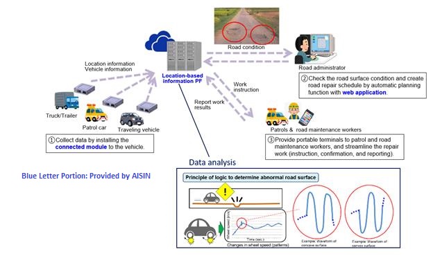
ARMS is a road damage detection software that leverages the Aisin Location-Based Services(LBS) Platform’s high-accuracy location data and machine learning algorithms to deliver accurate, real-time data on roads and infrastructure. Through automation of the and helps to reduce the costs and resources associated with road survey activities. By simply installing the ARMS edge computing unit and HD image camera, municipalities can capture crucial road condition data from vehicles that perform routine activities such as garbage collection and street cleaning.

In the US nationwide the percentage of roads classified as “poor condition” rose from 14% to 20% between 2009-2017. This comes to a roughly $786 billion backlog of badly needed road and bridge repairs. 37 states report that the condition of their roads are deteriorating at an increasing rate. Due to these road conditions, on average motorists pay over $1000/year in wasted time, fuel, and maintenance.
Features of ARMS
ARMS originated as a road damage detection software that utilized vehicle sensor data to detect potholes. By analyzing wheel speed and suspension data, Aisin was able to detect surface anomalies including potholes and surface unevenness. ARMS now leverages HD image camera technology to capture road surface imagery and analyzes it with Aisin’s proprietary AI algorithms and deep learning library to accurately detect a wide range of road surface defects.
Currently, ARMS is able to detect potholes and cracks as well as pavement ride quality as measured by the International Roughness Index (IRI). ARMS rates the severity of the defect using a proprietary scale. It can also be customized to the measurement needs of the municipality and integrated with existing defect scales. ARMS, along with road surface defects, can also detect weather-related issues such as snow and ice. It can also track municipal assets such as street signs, safety barriers, and sidewalks with its HD image camera, thus giving municipalities more data on their managed assets.